
What is involved when planning an overland trip through Africa?
There are many important considerations, including your route, daily distances, road conditions, accommodation, fuel availability, border crossings and the places you want to explore along the way. Today, however, we are going to focus specifically on route planning.
For anyone planning an overland journey through Africa, I highly recommend Tracks4Africa.
Why I Chose Tracks4Africa
Tracks4Africa has been developed specifically for travellers exploring Africa. Its online Trip Planner allows you to create routes, calculate distances and organise the different stages of your journey before you leave. You need to register for a Tracks4Africa account, after which you can access its planning and navigation services.
There are also several useful instructional videos and help guides available. I recommend watching these before beginning your route planning because they make it much easier to understand the platform and its different features.
I used Tracks4Africa to plan my forthcoming journey through Zambia, Botswana, Namibia and South Africa.
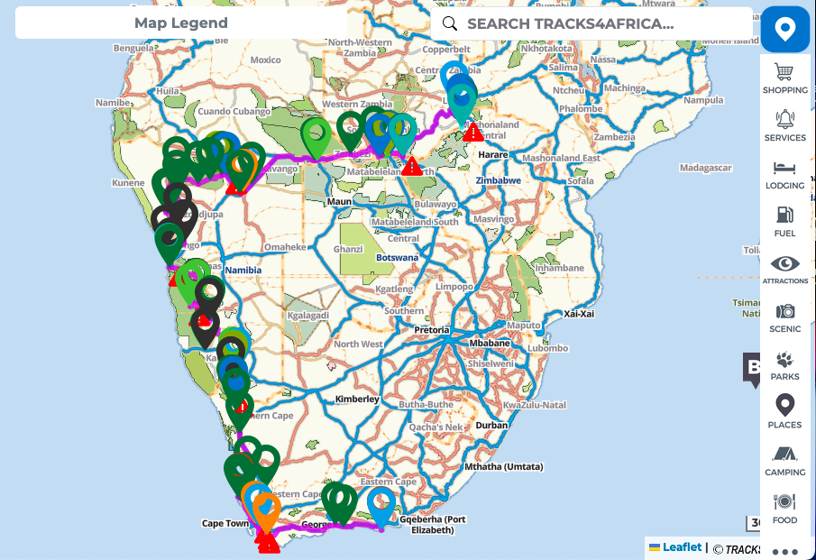
Why did I choose it?
Quite simply, it understands African overland travel better than most conventional navigation platforms.
Distance Does Not Always Equal Travel Time
When travelling through Africa, distance alone does not tell you how long a journey will take.
For example, 100 kilometres on a good tar road may take approximately one to one-and-a-half hours. However, the same distance on a badly corrugated gravel road or through thick Namibian sand could take three or four hours—or even longer.
Road conditions, terrain, weather, wildlife, water crossings and border formalities can all affect your progress.
This is where Tracks4Africa becomes particularly useful. It uses overland travel data to provide more realistic routes, distances and estimated travelling times. This helps you avoid planning days that look manageable on a conventional map but become exhausting or unsafe once you encounter the actual terrain.
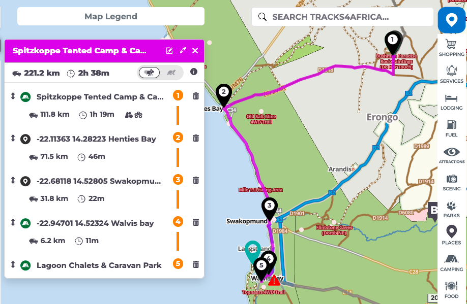
This section of my route demonstrates how individual stops can be added within a single travelling day. Rather than navigating directly from Spitzkoppe to Walvis Bay, I can include Henties Bay, Swakopmund and other places of interest along the way. Tracks4Africa recalculates the distance and travelling time for every section, helping me determine whether the complete day remains realistic.
Plan Time to Enjoy the Journey
One of the great pleasures of overlanding is arriving at camp with enough time to relax.
You want to be able to set up your campsite, unfold the awning, prepare a braai, cook dinner and enjoy the surroundings before getting a good night’s sleep. Arriving after dark because you underestimated the road conditions can turn an enjoyable day into a stressful one.
Route planning should therefore not be about covering the greatest possible distance. It should be about creating a realistic journey that gives you time to experience the places you are travelling through.
Africa offers extraordinary attractions along these routes, including:
- Wildlife reserves and national parks
- Lookout points and mountain passes
- Ancient rock-art sites
- Sand dunes and desert landscapes
- Rivers, waterfalls and canyons
- Remote coastal scenery
- Historic towns and cultural attractions
Tracks4Africa includes many of these destinations and points of interest. You can add them to your journey while planning each day’s route.
Finding Campsites
Accommodation is another essential part of route planning.
Using the Trip Planner, you can search for campsites in the area you intend to visit. Once you have selected a campsite, you can assess its position in relation to your route and calculate the approximate distance and travelling time required to reach it.
This allows you to divide a long expedition into manageable daily sections.
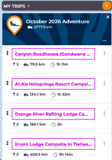
Once the general route had been established, I divided the expedition into individual travelling days. Tracks4Africa displays each stage separately, including the distance and estimated travelling time between the selected overnight stops. My complete planned route currently covers approximately 5,778 kilometres, although the final distance will probably increase once local excursions, game drives and unplanned diversions are included.
However, a campsite appearing on a map does not necessarily mean that it is currently open or that space will be available. Wherever possible, contact the campsite directly before travelling, particularly during peak seasons or when visiting remote areas with very few alternatives.
Campsite Information and Traveller-Sourced Updates
Tracks4Africa does much more than simply show where a campsite is located. For many campsites and lodges, additional information is available, including a description of the property, contact details, facilities, activities, rates and photographs where these have been provided. This makes it easier to compare possible overnight stops and contact the establishment directly before travelling.
This information is particularly valuable in remote areas, where accommodation options may be limited and an unsuitable campsite could leave you with a considerable distance to travel before reaching an alternative.
Another strength of Tracks4Africa is that much of its information has been built from the experiences of travellers who have driven these routes themselves. Overlanders can submit new places, corrected contact details, road information and other useful observations. Tracks4Africa then uses these submissions to update its maps, guides and travel information.
The downloadable Garmin map subscription includes updates during the subscription period. Tracks4Africa aims to release updates quarterly, which could mean as many as four updates during a year, although its general upgrade policy states that the number may depend on whether there have been sufficient map-content changes. It guarantees at least two updates per year under that policy.
This means that when travellers report significant changes—such as a road being washed away, a track becoming impassable, a campsite closing or a new route becoming available—the information may be incorporated into a future map update after it has been reviewed.
For example, a road that was previously considered passable may have been damaged during heavy storms. A later Tracks4Africa update could identify the changed road conditions or provide corrected routing information to help travellers avoid the affected section.
However, no digital map can guarantee that every recent road closure or washaway has already been reported and processed. In remote Africa, conditions can change quickly. It is still wise to speak to campsite owners, park officials, border authorities and other overlanders before entering particularly isolated areas.
Tracks4Africa gives you the best available information for planning, but local confirmation remains an important final precaution.
Planning Your Fuel Stops with Tracks4Africa
Fuel management is one of the most important parts of African overlanding.
Tracks4Africa identifies possible fuel stations along your route, helping you determine where you may need to refuel. However, never assume that every listed station will have fuel available when you arrive. Remote stations may occasionally run out of petrol or diesel, experience electricity problems or be temporarily closed.
Your vehicle’s fuel consumption will also change considerably according to the terrain.
For example, a loaded 4×4 travelling on a good road may achieve somewhere between 8 and 11 kilometres per litre. Once four-wheel drive is engaged and the vehicle is moving through thick sand, consumption could fall to approximately 5 kilometres per litre.
These figures will vary according to the vehicle, load, tyre pressure, speed, wind, road conditions and driving style. Therefore, calculate your fuel range conservatively rather than relying on your best-ever consumption figure.
One of the basic rules we follow is simple:
Whenever reliable fuel is available, consider topping up—especially once the tank falls below half full.
It is also sensible to carry reserve fuel in an approved fuel container. The container should be securely mounted in a safe external position, away from passengers, heat sources and anything that could damage it. Fuel storage must also comply with the regulations of every country and border crossing on your route.
Reserve fuel should be treated as an emergency backup, not as an excuse to stretch the distance between planned fuel stops.
Navigating Without Mobile Reception
Many remote parts of Africa have limited or no mobile-phone coverage.
Google Maps can be used offline when the appropriate map areas have been downloaded beforehand. However, it may not include the same level of information about remote tracks, overland campsites, terrain-specific travelling times and Africa-focused points of interest.
Tracks4Africa allows planned trips and routes to be synchronised with its app for offline use. Routes can also be exported in GPX format for compatible Garmin devices. Tracks4Africa additionally sells Garmin-compatible maps as downloads or on an SD or microSD card, depending on the device being used.
A dedicated GPS unit provides valuable redundancy when travelling beyond mobile coverage. Nevertheless, electronic navigation should never be your only system. Carrying a suitable paper map and maintaining a written record of important destinations, coordinates and emergency contacts is still good overland practice.
Including Border Crossings in the Route
Border crossings should be added as specific waypoints rather than treating the route as one uninterrupted journey between campsites.
In this example, Tracks4Africa has divided the journey from Ihaha Rest Camp to Camp Kwando into two stages, with the Ngoma Bridge border crossing included between them. This allows me to see how far I must travel before reaching the border and how much further I will need to drive after completing the immigration and customs formalities.
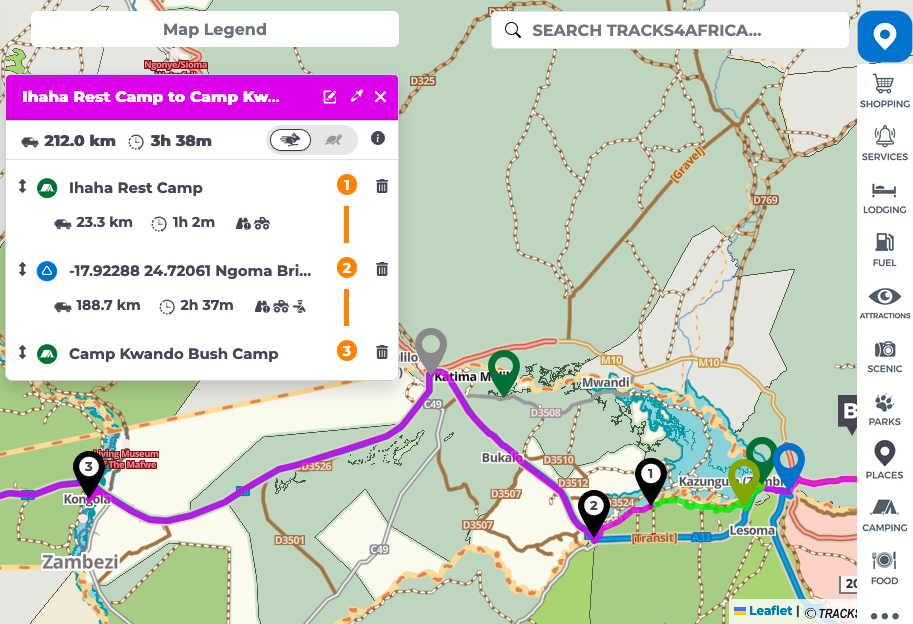
The driving-time estimate does not necessarily include the time spent completing border procedures. Therefore, additional time must be allowed for passport control, customs inspections, vehicle documentation, road permits, insurance and possible queues.
Preparation Creates Freedom
Good route planning does not remove the adventure from overlanding. It gives you the freedom to enjoy it.
By understanding the terrain, calculating realistic travelling times, identifying fuel stops, locating suitable campsites and planning the places you want to visit, you reduce unnecessary stress once the journey begins.
Tracks4Africa brings much of this information together in one platform, making it an exceptionally useful planning tool for an African overland expedition.
The goal is not merely to reach the next destination. It is to arrive safely, with enough fuel, enough daylight and enough energy to enjoy the experience.
Because the true pleasure of overlanding is not simply where you end up.
It is everything you discover along the way.
Ready to Plan Your Own African Adventure?
Route planning is one of the most exciting—and important—parts of any African overland journey. The better prepared you are before departure, the more freedom you will have to enjoy the wildlife, landscapes, campsites and unexpected discoveries along the way.
Explore the official Tracks4Africa website to learn more about its maps, navigation products and African travel resources. You can also create an account and begin building your own journey using the Tracks4Africa online Trip Planner. The planner is currently available free of charge while it remains in beta, although Tracks4Africa has indicated that it is intended to become part of a paid annual subscription service in the future.
My own route is only the beginning. Follow Dr Ron Van As – Travels With Tau on YouTube as I prepare Tau, cross borders and travel through Zambia, Botswana, Namibia and South Africa.
For questions, further information or to follow the written expedition journal, visit DrRonVanAs.com.
Plan carefully. Travel responsibly. Stay curious—and enjoy everything Africa reveals along the way.
FOLLOW TRAVELS WITH TAU ON YOUTUBE



2 Comments
Uwe Schmidthaus
Do you have space in your truck for two more
admin
Uwe, one day when my truck grows up to be a big Iveco like your amazing rig, you will be top of the list of candidates to join the adventure.